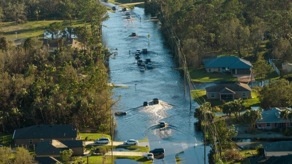
Cape Breton is dealing with a dangerous combination of flooded roads, washed-out routes, power failures and more rain still to come after a slow-moving system soaked the island. Environment Canada’s orange-level warning calls for 100 to 200 millimetres in some areas through Monday morning, with localized rainfall rates of 20 millimetres an hour or more and possible damage to critical infrastructure.
By Saturday afternoon, the impact was already visible across Richmond County and other parts of the island. Highways and local roads had closed, ferry service was disrupted, some residents were cut off by washouts and thousands had experienced power outages. Preliminary measurements suggested that a few localized spots may already have exceeded 200 millimetres, raising the stakes as saturated ground faces additional rain.
Rainfall Warning Escalates as the System Stalls
Cape Breton entered Saturday under an orange-level rainfall warning after Environment Canada raised both its confidence and expected totals. The agency said a slow-moving weather system was producing very heavy rain across the island, with 100 to 200 millimetres possible by Monday morning. In the hardest-hit pockets, rainfall rates could reach or exceed 20 millimetres an hour, fast enough to overwhelm drainage systems and turn low spots into dangerous crossings.
The warning was more serious than forecasts issued a day earlier, when totals of 100 to 150 millimetres were expected in eastern Nova Scotia. By Saturday morning, Environment Canada was explicitly warning that localized flooding was likely, roads could become impassable and some critical infrastructure could be damaged. The timing matters because the system is lingering rather than sweeping quickly offshore, giving saturated ground, ditches, culverts and streams little time to recover between bursts of rain through the long weekend.
Some Local Rain Gauges Have Already Passed 200 mm
The forecast ceiling was already being tested by midday. Environment Canada meteorologist Samantha Roach told Acadia Broadcasting that the official monitoring station at Port Hawkesbury had recorded 118 millimetres. Unofficial observations submitted from other parts of Cape Breton were even higher: 219 millimetres at St. George’s Channel, 178.6 millimetres in the Boisdale Hills and 230.1 millimetres in Sampsonville. Those unofficial numbers still require the caution applied to backyard or volunteer gauges, but they illustrate how sharply rainfall can vary across distances.
Even after the most intense overnight period had passed, the storm was not finished. Roach said another 40 to 60 millimetres could fall before rain tapered toward Sunday morning, with showers lingering afterward. That raised the possibility of more flooding even where rainfall rates eased. Once soil is saturated, water runs into ditches, brooks and culverts instead of soaking into the ground, increasing pressure on roads and drainage systems.
Highway Closures Turn Flooding Into a Transportation Emergency
The storm became a transportation emergency in Richmond County. Flooding shut a stretch of Highway 104 between exits 45 and 47, while a closure covered Highway 104 from Highway 320 to Highway 4. Acadia Broadcasting reported closures on Highway 4 near Northside River Bourgeois Road, West Bay Road near Hedgerow Lane and Highway 223 between Bras d’Or Lake and Grand Narrows Drive. Local roads including Matthews, Morrison and Oban were closed after washouts.
The geography makes those closures disruptive. Cape Breton’s rural communities often depend on a limited number of connecting roads, so a washed-out culvert or flooded highway can force a long detour or eliminate vehicle access. Emergency officials urged motorists to use 511 Nova Scotia before travelling and to turn around at flooded sections. A road covered by water can hide a missing shoulder, damaged pavement or a washed-out culvert, making depth alone a measure of safety.
Ferry Suspensions Add to a Patchwork of Broken Connections
Flooding was not limited to pavement. Weather suspended the Englishtown and Little Narrows ferry services, removing two links used to cross water on the island. Elsewhere, Orangedale Road was closed in more than one location, and Big Brook Road was shut near Murray Road. The result was a patchwork of interruptions rather than one failure, complicating efforts to judge whether a trip that looked routine on a map was possible.
That uncertainty is why officials directed residents to live road information instead of relying on routes or habit. In a prolonged rain event, a road can deteriorate after a driver has started travelling, particularly where runoff is moving through culverts or across low terrain. Each closure also affects more than commuters: delivery vehicles, home-care workers, utility crews and emergency responders may need alternate access. When several links fail together, even communities without flooded homes can feel isolated by the storm.
Washed-Out Roads Leave Some Residents Unable to Get Out
For some residents, road damage turned inconvenience into isolation. Acadia Broadcasting reported that Wendy Abbott and neighbours in Richmond County could not leave by vehicle because roads had washed out on both sides. Abbott, who manages the Bras d’Or Lakes Inn in St. Peter’s, was due at a wedding but could not reach the property. Some employees made it by taking lengthy detours through River Bourgeois, where damaged roads had also been reported.
Her experience shows how quickly a flood disrupts ordinary plans even when a house itself remains intact. Abbott said her family still had electricity, a generator and enough groceries, giving them time to wait for repairs. Others may not have the same margin. A blocked road can separate residents from pharmacies, workplaces, relatives or medical appointments, while also slowing crews trying to restore power or inspect washouts. In rural areas, access is part of the emergency response.
CBRM Had Warned Residents to Prepare for 72 Hours
Inside the Cape Breton Regional Municipality, officials had been preparing residents for this disruption. On Friday, CBRM warned of significant rainfall and wind, advised households to be ready for 72 hours in case of power outages and urged people to finish preparations before flooding blocked roads. The municipality specifically cautioned that water-covered streets can conceal hazards such as displaced manhole covers, a reminder that urban flooding can be dangerous even when the current appears slow.
As reports began coming in, CBRM directed residents to use 311 for flooded roadways and its after-hours Public Works line overnight, while reserving 911 for emergencies. That reporting system matters during a widespread event because crews need to know where water is accumulating, where drainage is failing and which routes are becoming unsafe. It also gives residents a way to flag localized problems that may develop faster than a forecast or road map can capture.
Power Outages Complicate the Flood Response
Power failures added a layer to the emergency. Acadia Broadcasting reported that more than 5,000 customers in Port Hawkesbury and surrounding areas lost electricity at the peak Saturday morning. By about 3:30 p.m., more than 3,000 customers in Richmond County had been restored, although scattered outages remained. Earlier outage data also showed thousands without service across Cape Breton and Victoria County as the storm moved through.
Electricity is closely tied to flood resilience. Sump pumps, communications equipment, refrigeration and household water systems can be affected when the grid goes down. Nova Scotia Power says restoration begins with safety concerns, then substations and lines, followed by critical services such as hospitals, police, fire, water and communications. That order explains why households may wait even when crews are active nearby. CBRM’s 72-hour preparedness advice was designed for this overlap: flooded roads can slow repairs while outages make coping with water more difficult.
Comfort Centres Become Part of the Emergency Network
Comfort centres became part of the response as road and power problems spread. Acadia Broadcasting reported that St. George’s Channel Hall, Riverdale Community Centre in Lower River Inhabitants and D’Escousse Civic Improvement Hall were opened to give residents places to charge devices, warm up and get support. With roads washed out and electricity failing in multiple communities, those facilities function as practical pieces of emergency infrastructure.
Their usefulness also depends on access. A comfort centre several kilometres away offers little help if the only connecting road is under water, which is why emergency planning often relies on multiple sites rather than one centralized location. CBRM’s preparedness guidance points residents toward NS Alert, 511, 311 and other emergency contacts so information can move even when travel cannot. During a flood, knowing which route is open, where help is available and whether conditions are worsening can be as important as having supplies.
Culverts Show Why “Critical Infrastructure” Is More Than a Warning Phrase
The phrase “critical infrastructure” is not abstract in Cape Breton. Roads, bridges, culverts, power lines, water systems and communications depend on one another during an emergency. Nova Scotia says its Public Works network includes roughly 23,000 kilometres of roads and 4,100 bridges provincewide, while its flood guidance notes that flooding can damage transportation links and interrupt vital services. A failed culvert can become a road washout, cutting access for residents and responders.
Cape Breton has been investing in that weak point. In 2024, Nova Scotia and CBRM committed $1.5 million to replace undersized culverts on Hickman Street and Rosewood Avenue in Glace Bay. The province said the work was intended to reduce flood depths on Reserve Street and lower flood risk for 43 properties. Projects like that show why drainage capacity matters: when rainfall arrives faster than water can be moved downstream, a small structure can become a community-scale bottleneck.
Cape Breton Has Seen What Extreme Rain Can Do Before
Cape Breton has painful precedents for this kind of rain. In November 2021, another storm closed more than 25 roads across eastern Nova Scotia and Cape Breton, with washouts on the Cabot Trail. Preliminary totals included 211 millimetres at Ingonish Beach and 150 millimetres in Sydney. Sydney had also recorded 225 millimetres during the October 2016 Thanksgiving flood, which devastated the city and destroyed homes.
Those events do not prove that any single 2026 storm was caused by climate change. They do, however, underline the infrastructure problem identified in provincial climate assessments. Nova Scotia expects warmer conditions to bring more rain, increasingly intense rainfall events and about a 10 per cent rise in total annual precipitation by the end of the century. The province says heavier rainfall increases flood and erosion risk. For Cape Breton, repeated extreme-rain episodes turn drainage upgrades, resilient roads and reliable emergency access into long-term necessities.
