A Victoria Day weekend that began with patio weather in parts of Central Canada is also delivering a reminder that late spring in this country rarely moves in a straight line. Forecasts heading into the holiday show southern Ontario pushing to around 30 C, while mountain parks and high-elevation corridors in Western Canada have been dealing with snowfall warnings, slushy highways, and sharply colder air. That kind of contrast sounds dramatic, but it is also deeply Canadian: the same long weekend can bring sunscreen, furnace restarts, and snow shovels, depending on the postal code. What makes this stretch especially striking is not just the range itself, but how quickly it flips from one season to another, with warm ridges, cold troughs, and elevation all shaping a holiday forecast that looks different almost everywhere.
A Country Split Between July and January
This long weekend is a case study in how wide Canada’s weather map can open up in May. In the Greater Toronto Area, official forecasts were calling for highs of 30 to 31 C early in the week, while Banff and nearby mountain terrain were under snowfall warnings with heavy, wet accumulation and difficult travel. That is not just a big difference on paper. It means one part of the country is talking about patios, fireworks, and the first real burst of summer heat, while another is watching road conditions and wondering whether winter tires were removed too soon.
What makes the contrast feel even sharper is how close it lands to seasonal turning points. Toronto’s forecast highs were running about 12 degrees above its normal mid-May maximum of 19 C. In Banff, meanwhile, temperatures were sitting far below what many people picture for a long weekend in the mountains, with heavy snow and daytime highs near 4 C. The result is a holiday pattern that feels less like one national forecast and more like three or four seasons sharing the same calendar.
British Columbia’s Mountain Pass Reminder
British Columbia offered an early warning that holiday travel can still turn wintry fast at elevation. Environment and Climate Change Canada’s weather summary for the province reported measurable snow on several southern B.C. routes, including 17 cm at Paulson Summit, 9 cm at Begbie Summit, and 5 to 7 cm at Kootenay Pass. Separate highway alerts warned that snow levels had dropped enough to create low visibility and accumulating snow over key passes, exactly the kind of setup that catches drivers off guard after a stretch of warmer spring weather.
The contrast inside the province was just as telling. Vancouver’s forecast itself stayed relatively modest, with highs mainly in the mid- to upper teens through the long weekend. Yet on Vancouver Island and in high terrain, the air felt much chillier, with showers and near-freezing overnight temperatures in some areas. That split is part of the B.C. story every spring: the coast can look manageable, but interior and mountain travel can turn hazardous quickly. For anyone moving between regions, the forecast was less about one provincial trend than about how fast elevation changes the rules.
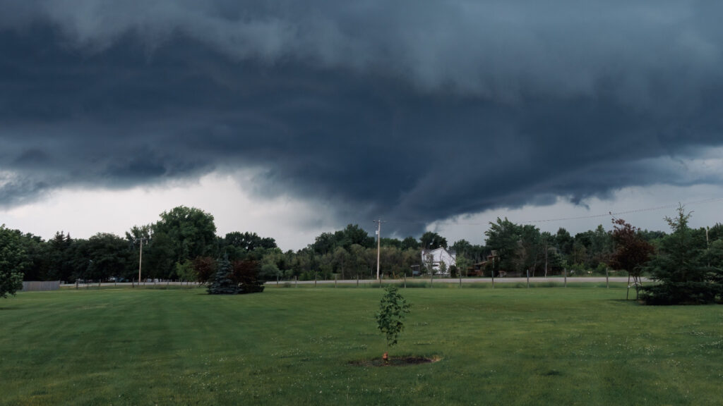
Alberta’s Long-Weekend Reversal
Alberta’s weather may be the clearest example of the weekend’s reversal. Calgary’s forecast called for periods of wet snow on Saturday, a daytime high near 5 C, and a low of minus 2 overnight, all well below the city’s normal mid-May maximum of 17 C. That is a jarring setup for the first big holiday of the warm season, especially in a city where gardeners, golfers, and road trippers usually treat this weekend as a soft launch into summer. It also shows how prairie sunshine one week can give way to slush and wind the next.
The mountain parks were even more dramatic. Banff and nearby high terrain were under snowfall warnings for 10 to 20 cm, with locally higher amounts possible, while some official warning text earlier in the event flagged 10 to 30 cm in the highest terrain and foothill-adjacent areas west of Calgary. Environment Canada also warned that much of the Trans-Canada Highway through the region could be affected. In plain terms, Alberta’s long weekend was not just cool. In parts of the province, it briefly looked and behaved like a return to winter.
The Prairies Turn Cold All Over Again
The Prairie forecast showed how a holiday weekend can swing from spring optimism back into stubborn chill within a day or two. Regina started Saturday near 12 C, but its official outlook then dropped into a soggy, raw pattern with rain on Sunday and daytime highs around 4 C, followed by another cool day near 7 C on Monday. Winnipeg looked even more locked in, with highs of only 8 C on Saturday, 11 C on Sunday, 8 C on Monday, and about 6 C on Tuesday before a nighttime rain-or-snow mix entered the forecast.
Those numbers matter because they are not just cool by feel; they are cool by May standards. Winnipeg’s normal mid-May high is around 20 C, so a forecast high near 6 to 8 C represents a major departure from seasonal expectations. This is the type of weather that changes the entire tone of a long weekend. Barbecues get moved indoors, lake plans get postponed, and jackets that had already been packed away suddenly return to the front hall. Across the Prairies, the holiday forecast did not simply cool off. It reset the mood.
Southern Ontario’s Sudden Summer Burst
If Western Canada supplied the snow headlines, southern Ontario supplied the heat. Official forecasts for Toronto called for highs of 31 C on both Monday and Tuesday, while nearby communities east of the city were forecast around 30 C and Ottawa was expected to push to about 29 C on Monday. That is a major jump for a region whose normal mid-May highs sit around 19 to 20 C. For many households, it meant the first truly summerlike stretch of the year arriving exactly when backyard gatherings, garden centre trips, and cottage departures tend to ramp up.
But the warmth also came with classic May complications. Toronto’s forecast included a risk of showers and thunderstorms before the hot spell, and additional shower chances as the heat lingered into Tuesday. That kind of setup often makes the air feel less stable than a clean midsummer heat wave. It is warm enough to tempt people into treating the weekend like July, but unsettled enough to remind them it still is not July. In southern Ontario, this was not settled summer weather. It was summer making a very loud entrance, then threatening to argue with itself.
Quebec’s Holiday Depends on Which Part of Quebec
Quebec’s long weekend forecast showed just how uneven this national pattern really is. Montreal was on track for a warm, increasingly muggy stretch, with highs climbing into the mid-20s and reaching about 27 C by Tuesday. Quebec City, by contrast, looked cooler and more unsettled, with Sunday near 17 C, Monday around 15 C, and rain on Tuesday with a high closer to 13 C. Those numbers do not describe a single provincial experience. They describe two very different versions of the same holiday, divided by geography, timing, and the path of the larger weather pattern.
There was also a useful safety reminder tucked into the forecast. Montreal’s official outlook specifically warned that entering cold bodies of water can lead to cold-water shock, even while daytime temperatures feel pleasant or outright warm. That disconnect catches people every spring. Air temperatures can make rivers and lakes seem inviting before the water has had time to warm anywhere near the same pace. In Quebec, the weekend forecast was not only about whether it would feel summery. It was also about whether conditions beneath the surface had actually caught up.
Atlantic Canada Stays Milder, but Not Uniform
Atlantic Canada avoided the headline-grabbing snow of the Rockies and the near-31 C spike seen in southern Ontario, but it still had its own split personality. Halifax’s official forecast showed a notably warm Sunday with a high around 25 C inland, though parts of the coast were expected to remain much cooler near 17 C under marine influence. That is a familiar East Coast twist: a fairly warm holiday can still feel much more subdued only a short drive from the open water. For planners, the postal code mattered almost as much as the day itself.
St. John’s told a different story again. Forecasts there pointed to a breezy, changeable stretch with highs around 13 C on Saturday, near 21 C on Sunday, then closer to 10 C on Monday before slipping cooler again. That kind of rise-and-fall pattern is less dramatic than a snowstorm warning, but it still shapes the weekend in obvious ways. In Atlantic Canada, the forecast was not built around extremes at both ends of the national chart. It was built around variability, coastal moderation, and how quickly comfort can change when ocean air takes over.
Why Canada Can Do This in May
There is a meteorological reason a Victoria Day weekend can feel like a cross-country season sampler. Environment Canada’s national weather analysis tools track the jet stream, highs, lows, and troughs that help separate warm and cold air masses over North America. When a warm ridge builds over one region while a cold trough digs into another, Canada’s size and topography amplify the contrast. Add mountains, lingering snowpack in higher terrain, and still-cold lakes and oceans, and the map can look chaotic even when the atmosphere is behaving in a fairly recognizable spring pattern.
It is also important to remember that winter-style hazards do not need to wait for winter. Environment and Climate Change Canada’s own glossary notes that winter storm conditions are not restricted to the winter season and may occur in late autumn and early spring. That makes this weekend unusual in degree, but not unbelievable in kind. In Canada, mid-May is old enough for heat, but still young enough for snow. This holiday simply happened to show both ends of that truth at once, with very little middle ground in between.
What This Weekend Really Says About Canada
The most revealing part of this forecast may be how ordinary the extraordinary can look in Canada. A long weekend that features sunscreen in the GTA, slush in Alberta, mountain snow in British Columbia, and rain-to-snow language in parts of Manitoba sounds almost cinematic when written in one sentence. Yet each region’s version of the weekend still fits the broader national script of spring transition, where warm and cold air do not politely take turns. They collide, overlap, and swap places fast enough to reshape plans by supper.
That is why Victoria Day often ends up functioning as a weather Rorschach test. In one city it feels like the opening scene of summer. In another, it looks like a last stubborn argument from winter. This year’s version is especially vivid because the swing is so easy to visualize: near-30 C heat in parts of Central Canada and heavy snow warnings in the mountain west at the same time. It is a reminder that a Canadian holiday forecast is never really one forecast. It is a moving national compromise between latitude, elevation, water, and timing.